Skip to content
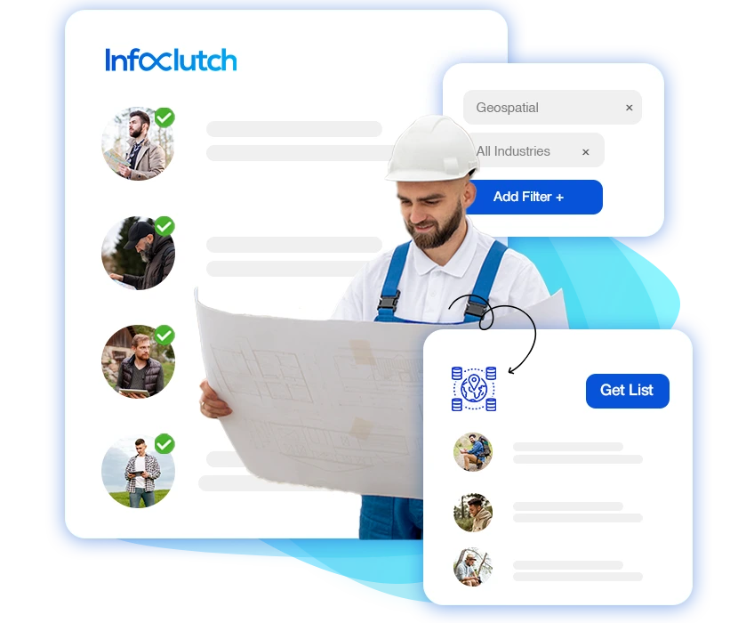
Geospatial Industry Email List
Any industry that requires location-based services is turning to geospatial solutions. Because of this, its market size will reach USD 617.84 billion in 2025.
The geospatial industry helps businesses and governments make informed decisions with the help of mapping, surveying, remote sensing, and GIS software. This field is highly innovative across the IT industry, and InfoClutch’s geospatial industry email list can make a difference!
If your services include GIS software, surveying equipment, or other geolocation solutions, we can connect you with top professionals like GIS analysts, cartographers, and key industry professionals with 4K+ verified contacts in our database!

1,718
Company Profiles

4,911
Total Contacts
Contact Us
We’ll Get Back To You Shortly!


21,359+ Companies Trust Us for their Data Needs
What is the Geospatial Industry Email List?
The geospatial industry email list is an extensive database of professionals and decision-makers in the geospatial IT sector. Geospatial decision makers’ email database includes contacts of GIS developers and analysts, surveyors, remote sensing specialists, photogrammetrists, and executives who influence industry trends and innovations.
Our geospatial email database is built using verified sources like government records, seminars, and professional directories. Each contact goes through a strict validation process, including email verification and tele-checking; we make sure to comply with industry standards.
Engage with industry leaders, promote your products or services, and expand your market reach with our reliable geospatial industry email list today!
Different Types of Sectors in Geospatial Industry Email Lists
InfoClutch’s geospatial industry email database includes contacts from many up-and-coming professions. Through this list, find decision-makers and top officials like:
| GIS Developers Email List | GIS Analysts Email List | GIS Technicians Email List |
| GIS Managers Email List | Software Engineers Email List | Surveyor’s Email List |
| Cartographers Email List | Photogrammetrists Email List | Urban and Regional Planners Email List |
| Geospatial Researchers Email List | Geospatial Analysts Email List | And more… |
Can’t Find the Email List You’re Looking for? Let Us Curate One For You.
Companies Currently In Geospatial Email Database
| Company Name | Website | Address | Address 1 | City | State | Zip Code | Country | Phone Number | Employee Size | Revenue | SIC Code | SIC Description |
|---|---|---|---|---|---|---|---|---|---|---|---|---|
| Allianz | www.allianz.com | Koeniginstrasse 28 | Munich | 80*** | Germany | 49 89***** | 157*** | **.3 B | 63** | Life Insurance | ||
| Country-Wide Insurance Company | www.cwico.com | 40 Wall Street | New York | NY | 100*** | United States | (212) ***** | 221*** | **.2 M | 63** | Life Insurance | |
| Health Care Service Corporation | www.hcsc.com | 300 East Randolph Street | Chicago | IL | 606*** | United States | (800) ***** | 280*** | **.7 B | 63** | Accident and Health Insurance | |
| MetLife | www.metlife.com | 200 Park Avenue | New York | NY | 101*** | United States | (646) ***** | 450*** | **.9 B | 63** | Accident and Health Insurance |
Why Choose InfoClutch as Your Geospatial Industry Email List?
The geospatial email list and contacts at InfoClutch have been ten years in the making. We have collected, verified, and cleansed our database through multiple channels of communication so you can contact highly responsive professionals and increase conversions.

Prospect with Area-specific Data
The advantage of a digitally advanced world is that you are not bound by geographic boundaries! Expand your reach and connect with clients globally using our location-specific data in the geospatial industry email list.
Regular Updates
Our geospatial industry email list is validated every 45 days. We also verify and cleanse the data before delivering a curated, up-to-date list to you.
Legally Sourced
Our geospatial email list ethically complies with CCPA, CAN-SPAM, and GDPR, reducing bounce rates and helping you connect with interested prospects.
Comprehensive Filters
With over 70+ precise and easy-to-use filters, you get to navigate through the geospatial decision-makers email database’s relevant contacts from industry sectors customized to your needs.
Multi-validated
We check every contact in our geospatial email database using both manual and automated processes. We ensure accurate and verified professionals and get rid of duplicate or deteriorated data.
Supercharge your Campaigns
We segment the geospatial industry marketing list based on customer behavior and industry trends for a 95% deliverability rate. So you can reach your marketing goals with highly targeted marketing campaigns and better results.
Seamlessly Connecting to your CRM
We use .xls, .csv, and .txt text file formats to share our lists with you. These popular formats are easily downloadable and ensure smooth integration into your CRMs without buffers or crashes.
Multi Vertical Success
All contacts in our geospatial industry email list are USPS-verified, CASS-certified, and DNC-compliant, providing you with high-quality leads for multi-channel communication.

Data Record Count
Who Can benefit the Geospatial Industry Email List?
The geospatial industry email list is best suited for:
- GIS Software Providers
- Surveying and Mapping Companies
- Remote Sensing Firms
- Urban Planners
- Smart City Developers
- Route Organizers
- Supply Chain Management Firms
- Real Estate Constructors
- Defense and Security Agencies
- Market Research Firms
What can the InfoClutch Geospatial Industry Email List do for you?
Geospatial solutions and geolocation in the IT industry have professionals who are always looking for innovators to collaborate with. Through our geospatial email list, you can directly reach industry leaders for:
Email Marketing
Our curated geospatial industry email list makes cold emailing and campaign outreach a lot easier by providing access to a highly relevant and specifically targeted audience.
Events and Conferences
Announce and market your industry events, webinars, and conferences directly to decision-makers and professionals who spearhead the geospatial industry.
Sales-based marketing
Use our advanced yet comprehensible filters to find and get in touch with the right prospects and increase conversion rates by targeting only interested professionals.
Product Launches
Launch your geospatial software and services by creating hype among a targeted IT audience that values innovative technology.
Market research
Reach out to experts, technicians, analysts, and managers for fresh and innovative trends to integrate them into your product or service.
Conventional Marketing
Analyze user behavior and pain points to craft highly effective marketing campaigns using our geospatial industry email list.
Lead Generation
Find high-quality leads across various geospatial industry sectors, reduce churn rates, and maximize conversions by connecting with high prospective clients.
Recruitment
Reach your hiring goals by connecting with skilled GIS professionals, surveyors, and remote sensing experts who match your recruitment needs. You can also reach out to and invite tech experts for guest speaking in your institution.
Networking
Build strong connections with GIS experts, mapping specialists, and industry leaders for potential collaborations, partnerships, and business growth through our geospatial email database.
Business-to-Client Process
Establish Goals and Milestones
Once we receive a client inquiry, our team will schedule a call to understand their business objectives and target audience. This helps us personalize the geospatial industry email list to meet their specific needs.
Building the geospatial Industry Email List
After identifying their requirements, our data experts and analysts compile a customized geospatial industry email list with verified and relevant contacts.
Delivering the geospatial industry mailing list
Once the customized geospatial industry email database is finalized, we deliver it in the client’s preferred file format (.xls, .csv, or .txt). Making it easy to download and smoothly integrate with their CRM.
Post-delivery support
We stay in touch with our clients throughout the geospatial email list curation journey and even after that for technical support and smooth delivery.
Customize the Geospatial Industry Email List to suit your needs
We have over 70 filters based on contact name, sector, work experience, location, technographic, company revenue, company size, and a lot more. Find the data based on your requirements and contact officials in high places to promote your software or brand to increase its value.
| First name | Area of Specialization | Ownership Type | Postal Address |
| Last name | Industry | Company Size | Geographical Location |
| Job Title | NAICS Code | Company Revenue | Demographics |
| Official Email | SIC Code | Company Website | Technographics |
| Work Experience | Entity Type | Assets Size | And More! |
Purchase Your Curated Geospatial Email Database Now!
About the Geospatial Industry
The geospatial industry is relatively new to the market, and yet it had a market size of USD 548.07 billion in 2024 and will go up to USD 617.84 billion in 2025. This shows a CAGR of 12.7%, which is the result of high demand for infrastructure development, environmental monitoring and conservation, smart cities, and precision agriculture.
The geospatial IT industry uses digital technologies like GIS, GPS, and remote sensing to collect and analyze location-based data. It helps businesses, governments, and researchers with mapping, urban planning, disaster management, and environmental decisions.
In the IT sector, geospatial technology integrates with big data, AI, cloud computing, and IoT to enhance location-based services. IT professionals use it for software development, predictive modeling, automation, and digital mapping.

Categories in the Geospatial Industry
Geospatial solutions can be divided into three different segments:
Technology
The geospatial industry uses advanced technologies like GIS, GPS, remote sensing, LiDAR, geospatial analytics, AI, cloud-based GIS, and indoor positioning. All of these technologies help track and survey data in specific locations.
Application
Geospatial solutions are applied across a variety of industries for specific purposes. They include land mapping, traffic management, environmental risk assessment, emergency response, telecommunications, vehicle mapping, navigation, and market analysis.
End-user
This segment focuses on industries and organizations that use geospatial solutions. These organizations include government and private sectors like urban planning, land management, military planning, border security, farming, deforestation tracking, disease tracking, and property valuation.
Top Companies from the Geospatial Industry
Here’s a list of Geospatial companies that lead the industry
| Organization | Revenue (in Billion USD) | Country |
|---|---|---|
| Google, Inc | 348.16 | USA |
| Microsoft Corporation | 64.7 | USA |
| Oracle Corporation | 53 | USA |
| ESRI | 5 | USA |
| Bentley Systems Incorporated | 0.335 | USA |
| Alteryx, Inc | 0.97 | USA |
| Earth Blox | 0.0018 | Scotland, UK |
How Geospatial Industry Email Database is Unearthed at InfoClutch
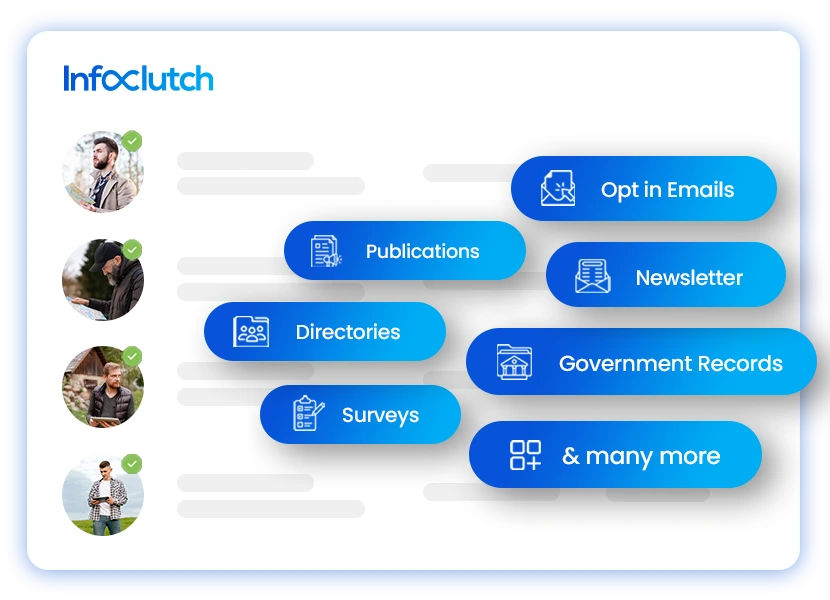
Our experts at InfoClutch are trained in geospatial email list data collection and analysis. We collect our geospatial industry email list data through 100% legitimate, valid, and certified global sources. They include opt-in emails, government records, seminars, surveys, newsletters, registries, business cards, directories, publishers, and many more.
All of our geospatial industry database passes and adheres to USPS, CASS, CCPA, DNC, CAN-SPAM, and GDPR acts, which also means our data has a very low bounce rate. Furthermore, the data goes through a multi-validation process; data is both manually and technologically checked.
Other Industry we serve
From software to solar industries, InfoClutch offers you comprehensive information on the key decision-makers and C-suite executives who spearhead the major industries around the world.
Through the lists curated by InfoClutch, connect with your target audience, amplify your brand value, smash the revenue goals you’ve set, and reap success!
- Energy Industry Email List
- Petrochemical Industry Email List
- Call Center/BPO Email List
- Wine Industry
- Semiconductor Industry Email List
- Furnishing Industry
- Legal Services
- Health & Beauty
- Oil and Gas Email List
- Retail Industry List
- Fitness Spa Clubs List
- Banking and Financial Services
- Advertising and Marketing
- Automotive Email List
- Food & Beverage Industry List
- Real Estate Email List
- Insurance Industry Email List
- Hospitality Email List
- Construction Industry List
- Business Services Industry Executives List
- Utility Industry Email List
- Transportation Industry Email List
- Media and Publishing Email List
- K-12 Schools Email List
- Solar Industry
- US Business Email List
- Telecom Email List
- Accouting & Payroll Industry
- Cloud Computing Industry List
- Consulting Services
- Computer Software
- Luxury Goods Industry List
- Medical Device Manufacturers
- 3D Printing Industry List
- Sericulture Industry List
- International Importers & Exporters List
- Supply Chain & Logistics Industry Email List
- Agriculture Industry Email List
- Forestry Email List
- Geospatial Industry Email List
- Electronics Industry Email List
- Aerospace/aviation Industry Email List
- Packaging Industry Email List
- Travel and tourism industry
- IT Industry Email List
- Mining Industry Email List
- Architectural Services
- Manufacturing Industry List
- Leisure Industry List
- Healthcare Email List
- Education Services Email List
- Life Science
- Chemical Industry List
- Pharmaceutical Email List
- Printing & Publishing Email List
- Biotechnology
- Concrete & Cement Industry List
- Poultry Farming Industry List
- and more...!
Join the 4000+ Successful Organizations that Trust our Data
Our multi-verified and clean data has helped 4000+ organizations over the past ten years. Every contact in our database goes through careful checks every 45 days and right before delivery to maintain verification of contacts for our clients.
No need to wait any longer! Get in touch with us to get InfoClutch’s geospatial industry email list today!
Place your order for a curated email industry list today at +1 (888) 998 007 or email us at [email protected] for more details, and we will get back to you as soon as possible!
Turn Prospects into Clients with InfoClutch’s Geospatial Industry Email List Today!
Testimonials
The words of our clients stand tall as a testament to our services and success. Here’s what they had to say about us!
Working with InfoClutch has been an incredible experience for us! They took care of our requirements with utmost precision, and the list they curated for us was authentic and had no false information. My team and I would like to thank the InfoClutch team for delivering their promise on time and helping us boost our campaign ROI. Thank you!
Having worked with several email list providers, I can confidently say that the InfoClutch team was the easiest to work with, and their list was an exceptional tool in our campaign success. The data they gave us was legitimate and fresh, and my team churned out more conversions than ever before. I highly recommend their services.
InfoClutch helped my team make our multichannel marketing campaigns more efficient with their data! Their list was of top-notch quality & had negligible bounce rates. Not only did we boost our ROI, but their team was in constant touch with us to ensure that the integration process was streamlined & smooth.
What I liked most about InfoClutch is their commitment to delivering impeccable services to their clients. They helped us figure out the requirements based on our campaigns and helped us boost conversions. Their responsive data was a huge influence on our email marketing campaigns.
When it came to our requirements, we had very specific needs that were left unanswered by many organizations. But ever since we started working with InfoClutch, they’ve worked in our best interest to get the requirements fulfilled. With their lists, we were able to communicate with genuine prospects and fulfill our requirements!
Questions
Frequently Asked Questions
The geospatial industry collects, analyzes, and uses location-based data on a specific location on Earth and uses it for mapping, navigation, and planning. It uses new location tracking technology like GIS and Earth observation.
It has become important recently in industries like urban planning, defense, logistics, and environmental monitoring because it helps these organizations carefully plan their operations, improve efficiency, and make strategic decisions.
Geospatial technology and solutions basically collect and survey data through geolocation mapping. For example, experts find and apply data on any place on Earth through tools like GIS, indoor positioning, and geospatial analytics.
Governments use it for urban planning and disaster management. Businesses use it for market analysis, logistics, and location intelligence. Industries like agriculture, real estate, and telecommunications rely on geospatial solutions for future planning.
The geospatial industry is growing with new-age AI-based analytics, cloud-based GIS, and real-time data processing. The new trends in the geospatial industry are 5G, IoT, and LiDAR technology.
They have highly improved data accuracy and accessibility, making geospatial solutions more valuable for industries like autonomous vehicles, smart cities, and environmental conservation.
At InfoClutch, our geospatial industry email list is built using verified, legally sourced data from emails, business cards, directories, seminars, and more. Each contact is validated on two levels: manual tele-checking as well as machine-checking.
This cleans our geospatial email database and improves accuracy, compliance, and relevance. We also update our database regularly to remove outdated or redundant contacts.
InfoClutch’s geospatial industry email list is built from authentic and legitimate sources like government records, business directories, and opt-in forms. Our verification process includes 100% compliance with USPS, CASS, CCPA, DNC, CAN-SPAM, and GDPR.
With InfoClutch’s geospatial industry email list, you can reach professional experts, C-suite executives, people in government positions, GIS professionals, and industry leaders.
Contacting them will help you increase engagement and conversions for your product or service. Whether for lead generation, networking, or marketing campaigns, our segmented data helps your business connect with the right audience.